What is behind the increasing popularity of Aerial Drone Photography.
As any person who has ever attempted to sell any property in the bustling real estate industry today, you understand that photos are the handshake first with the buyer. Conventional ground shots are effective in doing the job but not necessarily telling the whole story. And that is where real estate aerial drone photography comes in.
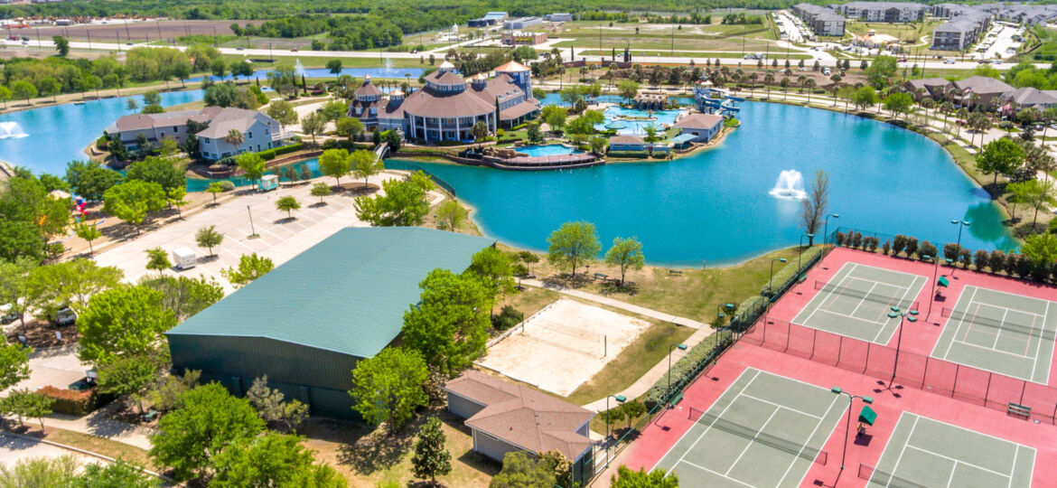
Buyers desire context, the size of the yard, how the house is located in the neighborhood, whether it is close to a park, school, some nearby lake, etc. That is immediately the viewpoint of a drone and it is this reason that aerial photography is no longer an incidental. Now it is one of the best selling marketing tools requested by realtors.
Benefits Aerial Drone Photography for Real Estate
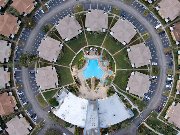
- Representing Property Scale and Layout.
Nothing can be depicted with still photos. Using the drone shots for property, the buyers will have a chance to view the driveway, backyard, pool, and roofline in a single frame. It is more of a birds-eye tour of them, before they even book a viewing. - It is important to point out the Neighborhoods and Amenities.
Real estate drone services don’t simply fly to take pictures of the house. They bring out the society. I have also been employed to take aerial shots of walking paths and playgrounds and shopping malls in the area. Such information assists consumers to imagine the kind of life outside the 4 walls. - Production of Filming Marketing Materials.
Drone video tours are cinematic. Listings are made to look like mini movies through slow flyovers across the front lawn or sweeping pans of a high-rise building. Such storytelling is something that touches the customers on an emotional plane and that is what motivates them to take action.
The operation of Drone Photography to Realtors.
How to plan aerial shots to be the most effective.
My most important shots are always planned before I take off a drone:
- Front elevation at an angle
- Direct overhead for lot size
- Facilities in the backyard such as pools or patios.
- Wider community views
Aerial Point of View Indoors vs. Outdoors.
Most individuals believe that drones are only used outdoors, however, in larger business outlets, I have used them inside in the dramatic fly-throughs of the warehouse. In residential it is all about the exterior, although some aerial sweeps indoors may enhance.
Legal and Safety.
Drones cannot fly everywhere. Being a real estate drone photographer, I will never fly without looking at airspace maps and making sure they comply with FAA. Safety is a must not negotiable- professionalism is reflected not only in the pictures but also the manner in which there is a responsible way of doing the work.
Comparing Aerial Photography With Traditional Photography
| Feature | Ground Photography | Aerial Drone Photography |
| Property scale visibility | Limited | Full view of lot & layout |
| Neighborhood perspective | Minimal | Clear, engaging context |
| Buyer engagement rate | Moderate | Higher click-throughs |
| Marketing impact | Standard | Cinematic & memorable |
The difference is clear: ground photography shows a property, while drone photography sells it.
Selecting a Drone Photographer of Real Estate.
- Skills and Certifications to search.
Find an FAA licensed photographer with professional equipment as well as portfolio of residential and commercial photography. - The Reason why Professional Editing Counts.
Shooting is half the job. Editing – color correction, replacement of skies, enhancement of real estate photos, etc. give drone photos a pop. Even the best drone shots may be ruined with poor editing. - The reason why Shoot2Sell Photography should be trusted.
We have invested both the art and the technology at Shoot2Sell Photography. Small condos to large commercial complexes, we provide images of drones and win deals at a faster pace than an agent. Realtors inform us that their listings become unique as soon as drone photos have been included.
FAQs Aerial Drone Photography for Real Estate
Q1: What is the price of aerial drone photography?
The price depends on size of property and package, yet it is quite cheap compared to what it gives in marketing.
Q2: Are drone shots effective in selling homes at all?
Yes. Posts that feature aerial photographs tend to receive more hits on the Internet and increased viewing. That additional involvement normally results in faster demonstrations.
Q3: Does the drone photography have permission everywhere?
No. There are certain airspaces that are restricted such as those near the airports. Always deal with a licensed drone pilot that knows local regulations.
Q4: Is it possible to combine the aerial shots with 3D tours?
Absolutely. Most agents have incorporated use of Matterport tours in combination with drone shots to give a virtual experience.
Q5 What is the turnaround of aerial photos?
A majority of the shoots are shipped within 24 to 48 hours.
Conclusion Ideas- Take Listings to the Next Level by Adding Aerial Photographs.
I can compare listings I have photographed with merely ground-level images to the listings with drone coverage and the disparity is astounding. Buyers just relate better when they have a big picture.
As a realtor, you might be interested in keeping up with the curve or moving ahead of it using aerial drone photography of real estate is no longer a choice, but a necessity. You are not just selling a house with high-resolution drone shots, filming tours and additional editing. You’re selling a lifestyle.
And that is what makes clicks showings, showings sales.